 Latest update:
25 June 2018
Latest update:
25 June 2018

Mini Breeding Bird Surveys
Orange, Chatham, and Durham Counties
North Carolina
Addendum:
15 June 2023
Mini Breeding Bird Surveys began in 1999
when Haven Wiley and Ginger Travis organized the first Orange County survey
Haven Wiley continued organizing the surveys in three counties until 2020
In the following year, Allen Hurlbert and Bradley Saul assumed the organization
of Mini Breeding Bird Surveys for the coming decades
At that time, a new web site was created to present the instructions and the results --
please bookmark this current web site for the MBBS
A Mini Breeding Bird Survey (MBBS) is a small-scale version of the full
Breeding Bird Survey organized each year by the U.S. Fish and Wildlife
Service throughout North America.
An MBBS focuses on one county. Volunteers count birds seen or
heard along randomly chosen routes on secondary roads. The
objective is to determine the distribution of breeding birds in the county
and to assess any year-to-year changes in their numbers.
An annual MBBS began in Orange County (12 routes) in 1999, in Chatham
County (14 routes) in 2000, and in Durham County (8 routes) in 2002.
The number of routes in each county varies with the size of the
county.
Jump to more about
routes and counts! . . .
Jump to entering counts in eBird!
Entering all habitat codes . . .
Entering totals for all stops
Results from the first decade of MBBS (1999-2009)
results for each route (1999-2009)
some statistical analyses of trends for each species 1999-2009
A new decade for MBBS (2010 ...)
In 2010 we began to use eBird.org to store the results of our surveys.
Coordinated by the Cornell Laboratory of Ornithology and the
National Audubon Society, eBird.org is now a widely used database for
observations of birds worldwide.
By 2012 we had worked out kinks in this process . . .
and we covered all routes in Durham County . . .
and all but a few in Orange and Chatham Counties!
In 2015 we covered 26 of our 34 routes overall . . .
6 (of 8) routes in Durham . . .
10 (of 12) in Orange . . .
and 10 (of 14) in Chatham Counties.
We can do better!
Our goal is . . .
complete coverage in Durham and Orange . . .
and at least holding our own in Chatham!
Why eBird for reporting data?
By using eBird, our numbers become available fo anyone to use for
scientific analysis!
It is easier to start an MBBS in other counties or in
other states or wherever (see needs below)!
Reporting results by using eBird
Option for counting night birds (beginning in 2013) ... arrive at
the starting point 15 minutes early (45 minutes before sunrise,
approximately 5:15 at our time of year) and count all birds heard during
those 15 minutes, and then start your first 3-minute count and continue
the survey as usual. Enter counts for the extra 15 minutes in
the Comments box (see below for an example).
Once you have run your route (review
our procedures below) ...
add up the total number of each species for the entire 20 stops
log into ebird.org
(how to log
in)
after logging in, click the tab "Submit Observations" near the top
On the page that appears ...
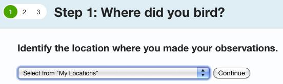
- choose your route in the drop-down menu "Select from My Locations" ...
- ... then click "Continue"
On the next page ...
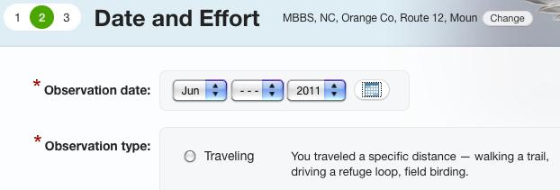
- enter the date you ran your route
- click the button for "Traveling"
... which expands the page so you can enter ...
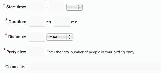
- the start time (usually 5:30 -- don't forget to add AM)
)
- the duration (within 10 minutes or so)
- the distance covered (always 10.0 miles)
- the number (of observers) in your party (normally 1 or 2)
- and "Comments" about your route
Your comments should include ...
- names of observers (for instance, "observers=Firstname Lastname, Firstname
Lastname")
- names of other participants such as driver or recorder (for instance,
"others=Firstname Lastname")
- weather such as temperature, cloud cover, and wind in general terms
(for instance, "weather=75F, partly cloudy, light wind, patches of fog early")
- the total number of vehicles during the 20 three-minute obervations
(for instance, "vehicles=23", with no spaces), and
- any change in the habitat at any stop (for instance, "habitat@16R=B",
with no spaces, meaning the new habitat code on the righthand side of the
route at stop 16 is now B)
- any other notes or observations (for instance, "notes=Cooper's Hawk flew
past after the count at stop 4, 3 Eastern Screech-Owls, 2 Barred Owls, 1
Great Horned Owl, 4 Whip-poor-wills, 2 Chuck-wills-widows during 15 minutes
before the start")
- use semicolons to separate these types of information (also omit
the quotes from the examples above)
- here's an example of a complete entry in this box ...
observers=Haven Wiley, John Doe; others=Minna Wiley; weather=75F, partly
cloudy, light wind, patches of fog early; vehicles=23; habitat@4L=S; notes=1
Barred Owl in 15 minutes before the start
After entering these "Comments", click "Continue" to reach the final page
...
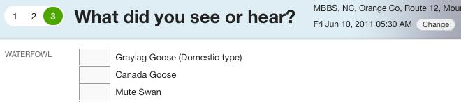
... where you can enter your totals in the appopriate boxes (scroll down
as necessary).
Once your totals are entered and you reach the bottom of the page ...
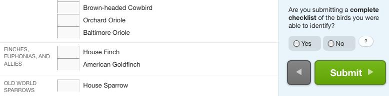
- click the button "Yes" for submitting a complete checklist
- and then click the big green button "Submit"
On the next page, you are congratulated on a job well done ...
"Your checklist has been submitted! Please review it carefully and make
any necessary changes."
Notice that you can change anything you have entered (if you made a
mistake).
Also notice the button near the top right corner "All Checklists".
Clicking this button takes you to a list of all checklists so far
submitted!
This list of checklists, allows you to "Edit" or "Delete" any of them (in
case you think of a mistake later ... but please do not delete anybody
else's list!). You can also "Share" your checklist with another
eBirder (or with your own eBird account).
Click the tab "My eBird" near the top to take you back to the MBBS home
page ... and finally "Sign Out" (although this step is not necessary if
you close your web browser or the current tab).
More comments on submitting reports
Choosing locations from the drop-down menu -- One reason for
shifting to eBird is that our data become available to anybody who would
like to analyze them. eBird follows the protocols for formatting
data in the Avian Knowledge Network, so data can be downloaded for
scientific study (it works although some programming is required!).
To allow our MBBS data to be identified for downloading, it is crucial that
the names of the locations of our routes follow strict formats
including spaces, commas, and capitalization. Using the drop-down
menu to select the location of an MBBS route solves this problem!
Vehicles and habitat codes -- A disadvantage of using eBird is
that there is no easy way to enter the total number of vehicles on a route
(those passing during the 20 three-minute observations) or any changes in
habitat codes from year to year. By adding this information in the
box for notes, it will be possible to retrieve it when data are downloaded
from the Avian Knowledge Network, provided we use the format suggested
above (for instance, "vehcles=17" and "habitat@7L=M").
Sharing MBBS checklists with your own eBird account -- It is
best to enter the data in the appropriate MBBS account and then share it
with your own account ... that way you can use the drop-down menu in the
MBBS account to select the location with the correct format ... all of the
species and numbers will also be tallied in your own account!
Locations and distances -- The locations of the routes are the
starting places (please let me know if you spot a significant
error!). eBird suggests using the coordinates for the aproximate
center of a traveling count, but for us the starting position is much more
critical. Although our routes only involve driving 9.5 miles from
stop 1 to stop 20, we include all birds recorded within 0.25 miles of the
first and last stops, so the total distance for an MBBS route is 10.0
miles.
More information about . . .
our procedures
(revised May 2006, updated September
2009)
including
descriptions and maps of our routes
a list of birds breeding in our area
and
printable forms for MBBS data
What we need now
Participants to pick up vacant routes
Qualifications -- ability to identify our breeding birds (especially the
regular ones) by song or calls as well as by sight -- interest in
out-of-the-way parts of the area where we live -- participation in
successive years (when possible) -- and, last but not least, willingness
to submit standard reports that can be used to evaluate trends in the
numbers of our breeding birds
County coordinators for Orange and Chatham Counties
Qualifications -- willingness to help in recruiting a few regular
participants when needed (see above) -- a few minutes each week (for
several weeks in the summer) to encourage participants to run their routes
and to enter their results in eBird in a timely way.
Coordinators for additional Mini Breeding Birds Surveys in
other counties, states, or elsewhere
To start a new MBBS, someone must select suitable routes (see the
guidelines in our procedures), use Google Earth (or a GPS device) to
obtain the coordinates of each starting location, spend a few hours with
eBird to set up an account with the locations for the routes -- and, most
important, recruit some partcipants!
It is also important to download and save the eBird checklists with each
year's results.
If you have questions, please contact
Patsy Bailey (Durham County) or
Haven Wiley.
|